Egypt has taken a major step toward modernizing its mineral exploration capabilities, with Minister of Petroleum and Mineral Resources Karim Badawi witnessing the signing of a Memorandum of Understanding (MoU) between the Egyptian Mineral Resources and Mining Industries Authority and Spain’s Excalibur Smart Mapping to launch a comprehensive national airborne geophysical survey.
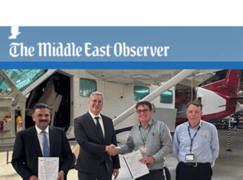
The agreement—signed during Badawi’s inspection visit to Excalibur’s operational base at Jandakot Airport in Western Australia—aims to deploy advanced aerial and satellite technologies to map Egypt’s mineral wealth with unprecedented depth and accuracy. The signing ceremony was attended by Yasser Ramadan, Chairman of the Mineral Resources Authority, and Bart Anderson, CEO of Excalibur.
According to a statement by the Ministry of Petroleum, the MoU covers wide-ranging cooperation including:
- Exchange of geological, technical, academic, and scientific data
- Joint participation in research and evaluation programs
- Risk assessment for targeted exploration zones
- Deployment of advanced surveying technologies and smart planning tools
The core objective is to establish a modern, integrated geological database for all of Egypt’s potential mining areas.
The national survey—one of the most extensive of its kind in the region—will cover all Egyptian governorates, with a focus on:
- The Eastern Desert (gold and rare metals belt)
- The Western Desert
- The Sinai Peninsula
- The Bahariya Oasis
- The Abu Tartour region
This aligns with Egypt’s broader strategy to attract mining investment, diversify sources of critical minerals, and develop upstream industries that feed into manufacturing, renewable energy, and high-tech sectors.
The project will be implemented in stages:
- Data Integration
Consolidating Egypt’s historical geological records with high-resolution satellite imagery to identify zones of interest. - Magnetic Airborne Survey
Launching aircraft equipped with magnetic and radiometric sensors to scan subsurface structures and pinpoint mineral-bearing formations. - Priority Targeting
Conducting detailed follow-up surveys in areas where early data indicates strong mining potential, enabling faster licensing and lower exploration risks.
This phased approach mirrors global best practices used in Australia, Canada, and South Africa to accelerate mineral discovery cycles and reduce uncertainty for investors.
During his tour in Western Australia, Minister Badawi inspected:
- Aircraft hangars and Excalibur’s specialized survey planes
- Sensor systems used for magnetic and electromagnetic data collection
- Real-time data acquisition platforms
- Safety and risk-management procedures for airborne operations
Officials emphasized that the partnership with Excalibur leverages the company’s global expertise in smart geospatial planning and airborne mapping, particularly in remote or complex terrain.
The initiative is considered a national milestone in repositioning Egypt as a competitive mining hub. A unified, high-resolution geological database is expected to:
- Reduce exploration costs
- Shorten the timeline for new discoveries
- Support transparent, data-backed mining tenders
- Attract international operators
- Increase the economic return of Egypt’s mineral resources
The MoU marks the latest step in the government’s plan to develop a mining sector capable of contributing more robustly to GDP, following reforms to licensing systems and partnerships with global geological survey leaders.